Level 1 Cloud Storage Downloader
How to download Landsat and Sentinel-2 Level-1 data from cloud services
Note
FORCE Level 1 CSD only provide Sentinel-2 and Landsat Collection 1 data. For downloading of Landsat Collection 2 data use force-level1-landsat.
This tutorial covers the process of querying and downloading Landsat and Sentinel-2 Level 1 data from cloud services (currently Google Cloud Storage). FORCE Level 1 CSD offers a high level of detail in requesting data and creates a consistent Level 1 data pool, as well as queue files that can be used for Level 2 processing.
Info
This tutorial uses FORCE v. 3.5
FORCE Level 1 CSD makes use of the Landsat and Sentinel-2 metadata catalogues from Google Cloud Storage to find scenes matching the user’s requirements and downloads them through gsutil. A check for scenes already existing locally is performed and only new scenes are downloaded.
Getting started
gsutil configuration
Currently, Landsat data can be downloaded without a login (this will change at some point), but downloading Sentinel-2 data requires authentication.
This is done through gsutil and only needs to be done once before the first run.
The credentials will be stored in a file called .boto in the user’s home directory (make sure to check the notes at the end of this document if you’re running FORCE in Docker).
Type the following command to start the authorization process
gsutil config
Follow the on-screen instructions to authorize access to the Google Cloud Platform APIs. When asked for a project name, just type in any name. It is not necessary to create a project first.
Downloading the metadata catalogues
The metadata catalogues contain metadata for all scenes stored on Google Cloud Storage.
The -u | --update option will download the latest (compressed) catalogues and extract them to the metadata directory specified by the user.
As the catalogues are fairly large (curently ~2.8 GB for Landsat and 5.9 GB for Sentinel-2), it is a good idea to place them in a shared location that can be accessed by several users.
force-level1-csd -u /data/Jakku/edc/level1/

Downloading Landsat metadata catalogue...
Extracting compressed Landsat metadata catalogue...

Downloading Sentinel-2 metadata catalogue...
Extracting compressed Sentinel-2 metadata catalogue...

Done. You can run this script without option -u to download data now.
The -s | --sensor option may be used if only one of the two catalogues need to be downloaded / updated.
Specifying one of the sensors of either family is sufficient (i.e., LT05 for Landsat or S2B for Sentinel-2).
Parameterization
Basic syntax
FORCE Level-1 CSD is parameterized with four mandatory arguments. These make up the core of the request and always need to be provided, while all remaining arguments are optional. The basic structure is visualized in the image below.
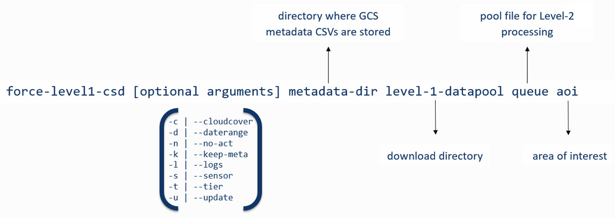
Mandatory arguments
metadata-dir
Directory where the metadata catalogues (csv file) are stored

level-1-datapool
An existing directory, your files will be stored here

queue
Downloaded files are appended to a file queue, which is needed for the
Level 2 processing. The file doesn't need to exist. If it does exist,
new lines will be appended on successful ingestion

area of interest
(1) user-supplied coordinates of your study area:
    The polygon must be closed (first X/Y = last X/Y). X/Y must be given as
    decimal degrees with negative values for West and South coordinates.
    Either specify the path to a file, or the coordinates on the command line.
    If in a file, provide one coordinate per line.
    If on the command line, provide a comma separated list.
(2) a shapefile (point/polygon/line). On-the-fly reprojection is provided,
    but using EPSG4326 is recommended.
(3) scene identifier:
    Landsat: Path/Row as "PPPRRR". Make sure to keep leading zeros:
      correct: 181034, incorrect: 18134
    Sentinel-2: MGRS tile as "TXXXXX". Make sure to keep the leading T before
      the MGRS tile number.
    You can either give the path to a file, or give the IDs on the command line.
    If in a file, provide one ID per line.
    If on the command line, provide a comma separated list.
The first three arguments specify the local directories for the metadata catalogues, the level 1 datapool (download directory), and the processing queue.
We define our area of interest with the fourth argument.
FORCE Level 1 CSD offers quite some flexibility in how the aoi can be specified.
Options (1) and (2) will intersect the provided geometries with the reference systems of Landsat and/or Sentinel-2.
Option (3) can be used if we already know which Landsat path/row or Sentinel-2 tiles we need.
Caution
If you would like to specify coordinates or a list of scene identifiers on the command line, keep in mind that the maximum length of command line calls is limited and varies by system! The lists may just be cut off and in the worst case you won’t notice before it’s too late. You may be better off storing them in a text file. Make sure this file uses UNIX end of line characters and provide one coordinate pair or grid identifier per line.
Optional arguments
Four of the optional arguments can be used to narrow down our search results:
-c | --cloudcover
minimum,maximum
The cloud cover range must be specified in %
Default: 0,100

-d | --daterange
starttime,endtime
Dates must be given in the following format: YYYYMMDD,YYYYMMDD
Default: 19700101,today

-s | --sensor
Sensors to include in the query, comma-separated.
Valid sensors:
Landsat                             Sentinel
LT04 - Landsat 4 TM                 S2A - Sentinel-2A MSI
LT05 - Landsat 5 TM                 S2B - Sentinel-2B MSI
LE07 - Landsat 7 ETM+
LC08 - Landsat 8 OLI
Default: LT04,LT05,LE07,LC08,S2A,S2B

-t | --tier
Landsat collection tier level. Valid tiers: T1,T2,RT
Default: T1
We can filter by cloud cover estimate, date range, sensor, and tier (Landsat only). If these parameters aren’t set, they will default to the values above.
Caution
Note that the default search is a very broad one. It will basically return all Landsat and Sentinel-2 scenes ever acquired for the area of interest. The only exception is the Tier level for Landsat - only Tier 1 scenes will be included, as Tier 2 and Real Time scenes are not desirable for most applications.
There are two further optional arguments that don’t affect the search parameters, but change the behavior of FORCE Level 1 CSD:
-n | --no-act
Will trigger a dry run that will only return the number of images
and their total data volume

-k | --keep-meta
Will write the results of the query to the level 1 datapool directory.
Two files will be created if Landsat and Sentinel-2 data is queried
at the same time. Filename: csd_metadata_YYYY-MM-DDTHH-MM-SS

-l | --logs
Check for FORCE Level-2 log files and remove any products from the search
that have been processed previously. Note that this only checks for the
presence of log files, not for actual Level-2 products.
Note
The mandatory arguments are positional!
They need to be provided in this exact order.
The optional arguments can be placed anywhere and may also be combined.
For example, -n -k -c 0,70 could also be written as -nkc 0,70.
When values are passed to the optional arguments (cloud cover, date range, sensor, or tier), these must be separated by commas , and must not contain whitespace.
Querying and downloading data
Basic search
Now that the FORCE Level 1 CSD is set up and we got the basic syntax straight, we can start looking for scenes that match our needs. Let’s start with a very broad search using a geopackage file defining our area of interest (the city-state of Berlin, Germany) as polygon feature.
To get a first overview of the data volume, we will use the -n | --no-act option.
This will print information about the results of our search without actually downloading the data.
force-level1-csd -n meta gcs_berlin/level1 gcs_berlin/level1/l1_pool.txt gcs_berlin/berlin_aoi.gpkg

Landsat and Sentinel-2 data requested.
Landsat data will be queried and downloaded first.

Searching for footprints / tiles intersecting with geometries of AOI shapefile...

Querying the metadata catalogue for Landsat data
Sensor(s): LT04,LT05,LE07,LC08
Tier(s): T1
Tile(s): 192023,192024,193023,193024
Daterange: 19700101 to 20201013
Cloud cover minimum: 0%, maximum: 100%

2510 Landsat Level 1 scenes matching criteria found
827.38GB data volume found.

Searching for footprints / tiles intersecting with geometries of AOI shapefile...

Querying the metadata catalogue for Sentinel2 data
Sensor(s): S2A,S2B
Tile(s): T32UQD,T33UUT,T33UUU,T33UVT,T33UVU
Daterange: 19700101 to 20201013
Cloud cover minimum: 0%, maximum: 100%

4152 Sentinel2 Level 1 scenes matching criteria found
1.78TB data volume found.

Done.
FORCE Level 1 CSD will print all details about the query parameters, as well as number of scenes found and total data volume for Landsat and Sentinel-2 data.
Refining the search parameters
Even though our area of interest is small, the data volume is substantial.
Let’s say we’re only interested in Sentinel-2B data from the year 2019 with cloud cover less than 70%.
We can use the -c | --cloud-cover to define the cloud cover threshold, -d | --daterange to only retrieve scenes between Jan 1, 2019 and Dec 31, 2019, and -s | --sensor to specify S2B as target sensor.
force-level1-csd -n -c 0,70 -d 20190101,20190430 -s S2B meta gcs_berlin/level1 gcs_berlin/level1/l1_pool.txt gcs_berlin/berlin_aoi.gpkg

Searching for footprints / tiles intersecting with geometries of AOI shapefile...

Querying the metadata catalogue for Sentinel2 data
Sensor(s): S2B
Tile(s): T32UQD,T33UUT,T33UUU,T33UVT,T33UVU
Daterange: 20190101 to 20190430
Cloud cover minimum: 0%, maximum: 70%

97 Sentinel2 Level 1 scenes matching criteria found
49.44GB data volume found.

Done.
That makes a huge difference - we’re down from 1.78TB to 49.44GB of data. However, considering the Sentinel-2 reference system, there still may be some redundancy in the data. We can see that FORCE Level 1 CSD found five MGRS tiles intersecting with the AOI. That’s quite a lot of tiles if we consider that Berlin covers less than 900km², while each S2 tile is 12.100km² large. Let’s take a look at how our area of interest is located in relation to the Sentinel-2 MGRS reference system:
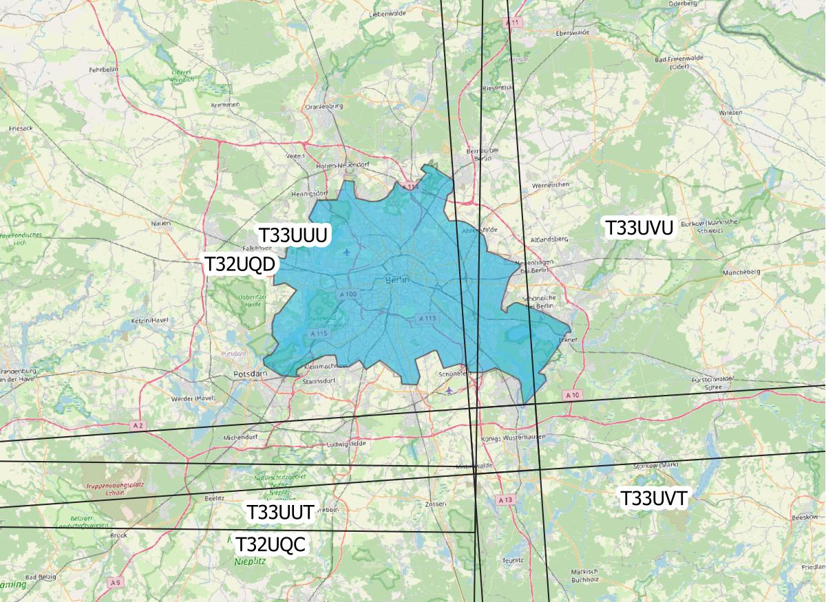
AOI (blue polygon) in relation to the Sentinel-2 reference system (black lines).
As we can see, the two northern tiles are probably sufficient to get all the data we need. The north/south overlap of T33UUU/T33UUT and T33UVU/T33UVT does not provide additional data, neither does the overlap of T33UUU and T33UQD. We can directly specify the desired tiles (comma-separated) as aoi:
force-level1-csd -n -c 0,70 -d 20190101,20191231 -s S2B meta gcs_berlin/level1 gcs_berlin/level1/l1_pool.txt T33UUU,T33UVU

Querying the metadata catalogue for Sentinel2 data
Sensor(s): S2B
Tile(s): T33UUU,T33UVU
Daterange: 20190101 to 20190430
Cloud cover minimum: 0%, maximum: 70%

44 Sentinel2 Level 1 scenes matching criteria found
21.06GB data volume found.

Done.
Download
When we’re happy with the results, we can remove the -n | --no-act option to start downloading
force-level1-csd -c 0,70 -d 20190101,20191231 -s S2B meta gcs_berlin/level1 gcs_berlin/level1/l1_pool.txt T33UUU,T33UVU

Querying the metadata catalogue for Sentinel2 data
Sensor(s): S2B
Tile(s): T33UUU,T33UVU
Daterange: 20190101 to 20190430
Cloud cover minimum: 0%, maximum: 70%

44 Sentinel2 Level 1 scenes matching criteria found
21.06GB data volume found.

Starting to download 44 Sentinel2 Level 1 scenes


Downloading S2B_MSIL1C_20190119T101339_N0207_R022_T33UVU_20190119T121912(5 of 44)...

|===========                                                                            |  13 %
General notes
Scenes are stored in folders named after their corresponding path/row (Landsat) or MGRS tile (Sentinel-2). The status bar will update after every scene that has successfully been downloaded. Any scenes that have already been downloaded will be skipped and a notification will be printed. If the download was canceled at some point and a scene wasn’t fully downloaded, FORCE Level 1 CSD will delete that scene and redownload it.
Sentinel-2 scenes
The processing baseline for Landsat data is standardized by the Collection format. For Sentinel-2 we found that there were duplicate scenes with different processing baselines or processing dates. FORCE Level 1 CSD will check for duplicates and only download the version with the highest processing baseline or latest processing date if the processing baseline is the same.
Saving metadata
FORCE Level 1 CSD offers the possibility to save the metadata of the scenes that matched the specified requirements.
Having easy access to this kind of information can be very helpful when creating statistics and visualizations about data availability over time, cloud cover distribution over time, data volume (e.g., per sensor or year), etc.
Using the -k | --keep-meta option will save the results of the current query to the Level 1 datapool folder under the file name
csd_metadata_[platform]_YYYY-MM-DDTHH-MM-SS.txt
The timestamp refers to the time when the request was made.
[platform] refers to the satellite platform (Landsat or Sentinel-2).
The -k | --keep-meta option can be combined with the -n | --no-act option to acquire the metadata without downloading any data.
If Landsat and Sentinel-2 data is queried at the same time, two separate files will be created.
ls gcs_berlin/level1

csd_metadata_2020-10-01T19-48-16.txt
csd_metadata_2020-10-01T19-48-21.txt
l1_pool.txt
T33UUU
T33UVU
Note
When analyzing metadata, keep in mind that Google’s catalogues use different column names for Landsat and Sentinel-2.
head -n 1 edc/level1/metadata_landsat.csv
SCENE_ID,PRODUCT_ID,SPACECRAFT_ID,SENSOR_ID,DATE_ACQUIRED,COLLECTION_NUMBER,COLLECTION_CATEGORY,SENSING_TIME,DATA_TYPE,WRS_PATH,WRS_ROW,CLOUD_COVER,NORTH_LAT,SOUTH_LAT,WEST_LON,EAST_LON,TOTAL_SIZE,BASE_URL

head -n 1 edc/level1/metadata_sentinel2.csv
GRANULE_ID,PRODUCT_ID,DATATAKE_IDENTIFIER,MGRS_TILE,SENSING_TIME,TOTAL_SIZE,CLOUD_COVER,GEOMETRIC_QUALITY_FLAG,GENERATION_TIME,NORTH_LAT,SOUTH_LAT,WEST_LON,EAST_LON,BASE_URL
Information for Docker users
If you are running FORCE in Docker, there is a different user in the container than on the host machine.
This is a problem for gsutil as the config file is stored there by default.
You can work around this by mounting the folder where your .boto file is located (usually your home directory) and set an environment variable that points gsutil there.
For details about this, please see our instructions on Docker usage.
|
This tutorial was written by Stefan Ernst, contributor to FORCE, researcher at EOL. Views are his own. |
EO, ARD, Data Science, Open Science |
|